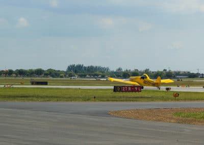
Location – North Perry Airport – KHWO
| FAA Identifier :HWO ICAO : HWO From city : 5 miles W of HOLLYWOOD, FL Region : Florida (All Airports in Florida) Localization: US-FL Latitude : 26-00-04.4000N |
Longitude: 080-14-26.6000W Field Elevation :8 ft. / 2.4 m (surveyed) Type: Airport (Airfield) Use: Time Zone :UTC -5 (UTC -4 during Daylight Saving Time) Country : United States |
| Publicly-owned
BROWARD COUNTY |
Manager
NINA MACPHERSON |
Runway Information
Runway 1L/19R
| Dimensions: | 3350 x 100 ft. / 1021 x 30 m | ||||
| Surface: | asphalt, in good condition | ||||
Weight bearing capacity:
|
|||||
| Runway edge lights: | medium intensity | ||||
| RUNWAY 1L | RUNWAY 19R | ||||
| Latitude: | 25-59.869825N | 26-00.422823N | |||
| Longitude: | 080-14.644605W | 080-14.640985W | |||
| Elevation: | 7.6 ft. | 7.2 ft. | |||
| Traffic pattern: | left | right | |||
| Runway heading: | 006 magnetic, 000 true | 186 magnetic, 180 true | |||
| Displaced threshold: | 350 ft. | 350 ft. | |||
| Markings: | basic, in good condition | basic, in good condition | |||
| Visual slope indicator: | 2-light PAPI on left (3.50 degrees glide path) | 2-light PAPI on left (3.50 degrees glide path) | |||
| Runway end identifier lights: | yes | yes | |||
| Touchdown point: | yes, no lights | yes, no lights | |||
| Obstructions: | 49 ft. tree, 1170 ft. from runway, 125 ft. left of centerline, 20:1 slope to clear RY 01L APCH SLOPE 31:1 TO THE DSPLCD THLD. |
32 ft. tree, 990 ft. from runway, 125 ft. left of centerline, 25:1 slope to clear RY 19R APCH SLOPE 41:1 TO THE DSPLCD THLD. |
|||
Runway 1R/19L
| Dimensions: | 3260 x 100 ft. / 994 x 30 m | ||||
| Surface: | asphalt, in good condition | ||||
Weight bearing capacity:
|
|||||
| RUNWAY 1R | RUNWAY 19L | ||||
| Latitude: | 25-59.851860N | 26-00.389932N | |||
| Longitude: | 080-14.379820W | 080-14.376160W | |||
| Elevation: | 6.9 ft. | 6.4 ft. | |||
| Traffic pattern: | right | left | |||
| Runway heading: | 006 magnetic, 000 true | 186 magnetic, 180 true | |||
| Displaced threshold: | 185 ft. | 110 ft. | |||
| Markings: | basic, in good condition | basic, in good condition | |||
| Visual slope indicator: | 2-light PAPI on left (3.50 degrees glide path) | 2-light PAPI on left (3.50 degrees glide path) | |||
| Runway end identifier lights: | no | no | |||
| Touchdown point: | yes, no lights | yes, no lights | |||
| Obstructions: | 42 ft. tree, 1026 ft. from runway, 125 ft. right of centerline, 20:1 slope to clear RY 01R APCH SLOPE 28:1 TO THE DSPLCD THLD. |
59 ft. tree, 1380 ft. from runway, 125 ft. left of centerline, 20:1 slope to clear RY 19L APCH SLOPE 25:1 TO THE DSPLCD THLD. |
|||
Runway 10R/28L
| Dimensions: | 3255 x 100 ft. / 992 x 30 m | ||||
| Surface: | asphalt, in good condition | ||||
Weight bearing capacity:
|
|||||
| Runway edge lights: | medium intensity | ||||
| RUNWAY 10R | RUNWAY 28L | ||||
| Latitude: | 25-59.893785N | 25-59.890597N | |||
| Longitude: | 080-14.653465W | 080-14.058972W | |||
| Elevation: | 6.9 ft. | 7.8 ft. | |||
| Traffic pattern: | right | left | |||
| Runway heading: | 096 magnetic, 090 true | 276 magnetic, 270 true | |||
| Displaced threshold: | 255 ft. | 210 ft. | |||
| Markings: | nonprecision, in good condition | basic, in good condition | |||
| Visual slope indicator: | 4-light PAPI on left (3.50 degrees glide path) | 2-light PAPI on left (3.50 degrees glide path) | |||
| Runway end identifier lights: | yes | yes | |||
| Touchdown point: | yes, no lights | yes, no lights | |||
| Obstructions: | 70 ft. bldg, lighted, 1618 ft. from runway, 20:1 slope to clear RY 10R APCH SLOPE 26:1 TO THE DSPLCD THLD. |
26 ft. pole, 477 ft. from runway, 250 ft. left of centerline, 11:1 slope to clear RY 28L APCH SLOPE 25:1 TO THE DSPLCD THLD DUE TO 63 FT TREE 1354 FT FROM RWY END BOTH SIDES OF CNTRLN. |
|||
Runway 10L/28R
| Dimensions: | 3240 x 100 ft. / 988 x 30 m | ||||
| Surface: | asphalt, in good condition | ||||
Weight bearing capacity:
|
|||||
| RUNWAY 10L | RUNWAY 28R | ||||
| Latitude: | 26-00.135937N | 26-00.132892N | |||
| Longitude: | 080-14.686928W | 080-14.095002W | |||
| Elevation: | 6.6 ft. | 7.3 ft. | |||
| Traffic pattern: | left | right | |||
| Runway heading: | 096 magnetic, 090 true | 276 magnetic, 270 true | |||
| Displaced threshold: | 181 ft. | 60 ft. | |||
| Markings: | basic, in good condition | nonprecision, in good condition | |||
| Visual slope indicator: | 2-light PAPI on left (3.50 degrees glide path) | 2-light PAPI on left (3.50 degrees glide path) | |||
| Runway end identifier lights: | no | no | |||
| Touchdown point: | yes, no lights | yes, no lights | |||
| Obstructions: | 35 ft. pole, 984 ft. from runway, 120 ft. right of centerline, 23:1 slope to clear RY 10L APCH SLOPE 34:1 TO THE DSPLCD THLD. |
55 ft. tree, 1400 ft. from runway, 200 ft. left of centerline, 22:1 slope to clear RY 28R APCH SLOPE 26:1 TO THE DSPLCD THLD |
|||
Other airports near North Perry Airport – KHWO
Miami-Opa Locka Executive Airport – KOPF
Fort Lauderdale/Hollywood International Airport – KFLL
Fort Lauderdale Executive Airport – KFXE
Miami International Airport – KMIA
Pompano Beach Airpark – KPMP
Why Choose West Palm Jets. to Book Private Jet Flights to and from North Perry Airport – KHWO?
West Palm Jets is an industry-leading private jet charter service provider offering exceptional and unrivaled standards in service, flexibility, efficiency and value by designing customized air travel solutions for each individual customer. Our clients demand the best from us, and we never compromise. We will exceed your expectations by providing world-class jet charter service, exceptional value and absolute flexibility on each and every jet charter flight.

Hollywood Quick Info
Country: USA
State: Florida
County: Broward
Coordinates: 26°1′17″N 80°10′30″W
Time zone Eastern
UTC -5/-4


