

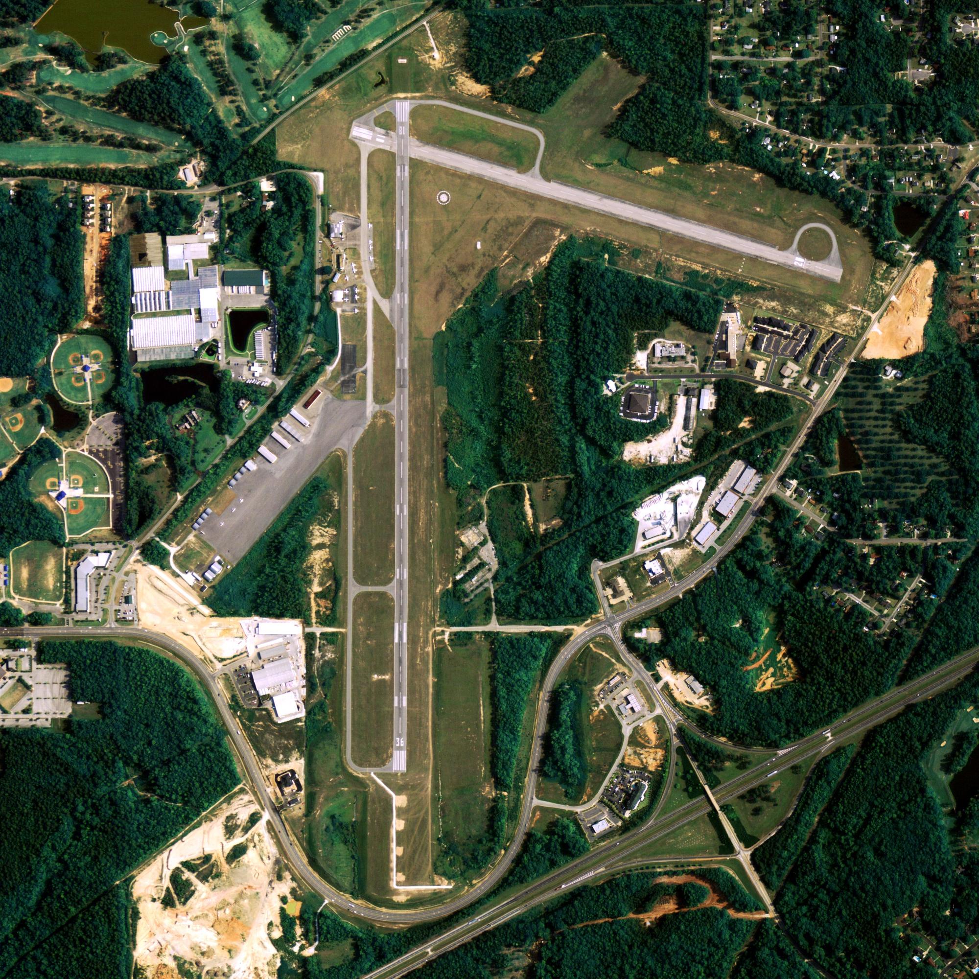
Location
| FAA Identifier: | BET |
| Lat/Long: | 60-46-42.8000N 161-50-13.8000W 60-46.713333N 161-50.230000W 60.7785556,-161.8371667 (estimated) |
| Elevation: | 128.8 ft. / 39.3 m (surveyed) |
| Variation: | 11E (2020) |
| From city: | 3 miles SW of BETHEL, AK |
| Time zone: | UTC -9 (UTC -8 during Daylight Saving Time) |
| Zip code: | 99559 |
Runway Information
Runway 1L/19R
| Dimensions: | 6400 x 150 ft. / 1951 x 46 m | ||||||||||
| Surface: | asphalt/grooved, in fair condition | ||||||||||
| Weight bearing capacity: |
|
||||||||||
| Runway edge lights: | high intensity | ||||||||||
| RUNWAY 1L | RUNWAY 19R | ||||||||||
| Latitude: | 60-46.306147N | 60-47.269648N | |||||||||
| Longitude: | 161-50.610210W | 161-49.754912W | |||||||||
| Elevation: | 127.2 ft. | 102.2 ft. | |||||||||
| Traffic pattern: | left | left | |||||||||
| Runway heading: | 012 magnetic, 023 true | 192 magnetic, 203 true | |||||||||
| Markings: | precision, in fair condition | precision, in fair condition | |||||||||
| Visual slope indicator: | 4-box VASI on left (3.00 degrees glide path) | 4-box VASI on left (3.00 degrees glide path) | |||||||||
| RVR equipment: | touchdown TOUCHDOWN RVR AVBL 0700-2000 1 NOV-30 MAR, 1 APR-31 OCT 0700-2200. |
touchdown TOUCHDOWN RVR AVBL 0700-2000 1 NOV-30 MAR, 1 APR-31 OCT 0700-2200. |
|||||||||
| Approach lights: | MALSR: 1,400 foot medium intensity approach lighting system with runway alignment indicator lights | MALSR: 1,400 foot medium intensity approach lighting system with runway alignment indicator lights | |||||||||
| Runway end identifier lights: | no | ||||||||||
| Touchdown point: | yes, no lights | yes, no lights | |||||||||
| Instrument approach: | MLS | ILS/DME | |||||||||
Runway 1R/19L
| Dimensions: | 4000 x 75 ft. / 1219 x 23 m | ||||
| Surface: | asphalt, in good condition MULTIPLE PAVEMENT VARIATIONS(DIPS)SCATTERED FULL LENGTH OF RWY 1R-19L ON BOTH SIDES OF CENTER LINE. |
||||
| Weight bearing capacity: |
|
||||
| Runway edge lights: | high intensity | ||||
| RUNWAY 1R | RUNWAY 19L | ||||
| Latitude: | 60-46.260398N | 60-46.862523N | |||
| Longitude: | 161-50.395015W | 161-49.860332W | |||
| Elevation: | 122.1 ft. | 116.8 ft. | |||
| Traffic pattern: | left | left | |||
| Runway heading: | 012 magnetic, 023 true | 192 magnetic, 203 true | |||
| Visual slope indicator: | 4-light PAPI on left (3.00 degrees glide path) | 4-light PAPI on left (3.00 degrees glide path) | |||
| Runway end identifier lights: | yes | yes | |||
| Touchdown point: | yes, no lights | yes, no lights | |||
Runway 12/30
| Dimensions: | 1858 x 75 ft. / 566 x 23 m | ||||
| Surface: | asphalt/gravel, in good condition SE 495 FT LENGTH IS ASPH. NW 1363 FT LENGTH IS GRVL. |
||||
| Weight bearing capacity: |
|
||||
| Runway edge lights: | medium intensity | ||||
| RUNWAY 12 | RUNWAY 30 | ||||
| Latitude: | 60-46.878963N | 60-46.689027N | |||
| Longitude: | 161-50.860840W | 161-50.372993W | |||
| Elevation: | 125.6 ft. | 126.8 ft. | |||
| Traffic pattern: | left | left | |||
| Runway heading: | 117 magnetic, 128 true | 297 magnetic, 308 true | |||
| Touchdown point: | yes, no lights | yes, no lights | |||
| Obstructions: | 168 ft. ant, marked, 5600 ft. from runway, 200 ft. left of centerline, 33:1 slope to clear | none | |||
Other nearby airports with instrument procedures:
- PAPK – Napaskiak Airport (5 nm S)
- PANA – Napakiak Airport (7 nm SW)
- PFKW – Kwethluk Airport (12 nm E)
- PFAK – Akiak Airport (19 nm NE)
- PFKA – Kasigluk Airport (21 nm W)
Bethel Quick Info
Country: USA
State: Alaska
Area
50.11 sq mi (129.78 km2)
Coordinates 60°47′32″N 161°45′21″W
Population
6,493 (2018 est)
Density: 330.75/sq mi (127.65/km2)
Time zone
UTC−9 (AKST)