

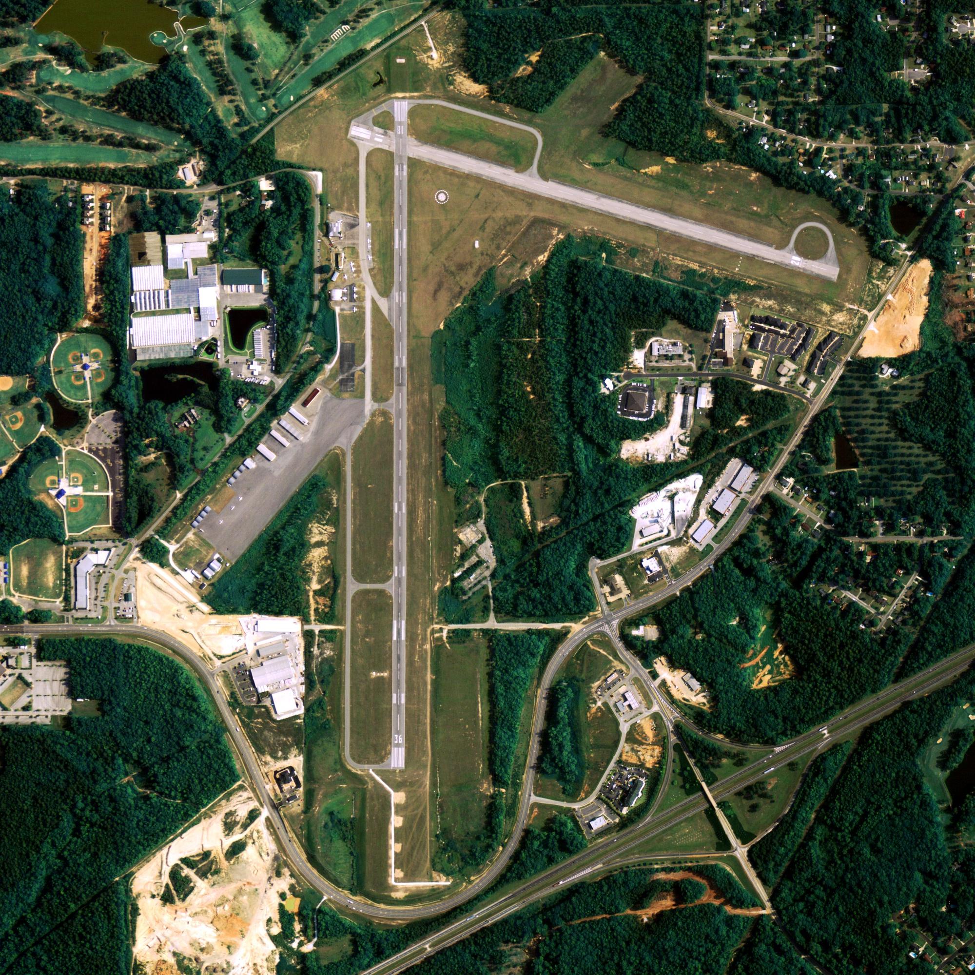
Location
| FAA Identifier: | MRI |
| Lat/Long: | 61-12-48.7622N 149-50-41.0069W 61-12.812703N 149-50.683448W 61.2135451,-149.8447241 (estimated) |
| Elevation: | 137.3 ft. / 41.8 m (surveyed) |
| Variation: | 19E (2010) |
| From city: | 1 mile E of ANCHORAGE, AK |
| Time zone: | UTC -9 (UTC -8 during Daylight Saving Time) |
| Zip code: | 99508 |
Runway Information
Runway 7/25
| Dimensions: | 4000 x 100 ft. / 1219 x 30 m | ||||||
| Surface: | asphalt, in good condition | ||||||
| Weight bearing capacity: |
|
||||||
| Runway edge lights: | medium intensity | ||||||
| RUNWAY 7 | RUNWAY 25 | ||||||
| Latitude: | 61-12.954167N | 61-12.954000N | |||||
| Longitude: | 149-51.198333W | 149-49.837333W | |||||
| Elevation: | 124.4 ft. | 136.7 ft. | |||||
| Traffic pattern: | right | left | |||||
| Runway heading: | 071 magnetic, 090 true | 251 magnetic, 270 true | |||||
| Markings: | precision, in good condition | precision, in good condition | |||||
| Visual slope indicator: | 2-box VASI on left (3.75 degrees glide path) | 2-box VASI on left (3.00 degrees glide path) | |||||
| Runway end identifier lights: | yes | yes | |||||
| Touchdown point: | yes, no lights | yes, no lights | |||||
| Obstructions: | 32 ft. pole, 245 ft. from runway, 300 ft. right of centerline, 1:1 slope to clear | 37 ft. bldg, 410 ft. from runway, 305 ft. right of centerline, 5:1 slope to clear | |||||
Runway 16/34
| Dimensions: | 2640 x 75 ft. / 805 x 23 m | ||||
| Surface: | asphalt, in good condition | ||||
| Weight bearing capacity: |
|
||||
| Runway edge lights: | medium intensity | ||||
| RUNWAY 16 | RUNWAY 34 | ||||
| Latitude: | 61-12.940833N | 61-12.507667N | |||
| Longitude: | 149-51.151000W | 149-51.151500W | |||
| Elevation: | 124.4 ft. | 117.1 ft. | |||
| Traffic pattern: | right | left | |||
| Runway heading: | 161 magnetic, 180 true | 341 magnetic, 000 true | |||
| Markings: | basic, in fair condition | basic, in fair condition | |||
| Visual slope indicator: | 2-box VASI on right (3.00 degrees glide path) | 2-light PAPI on left (3.00 degrees glide path) | |||
| Runway end identifier lights: | yes | yes | |||
| Touchdown point: | yes, no lights | yes, no lights | |||
| Obstructions: | 40 ft. bldg, 425 ft. from runway, 270 ft. left of centerline, 5:1 slope to clear | 26 ft. bldg, 200 ft. from runway, 220 ft. left of centerline, 1:1 slope to clear 26 FT BLDG, 220 FT L OF CNTRLN, 0-200 FT FROM RWY THR. |
|||
Runway 5/23
| Dimensions: | 2000 x 60 ft. / 610 x 18 m | ||
| Surface: | asphalt/gravel, in good condition | ||
| Operational restrictions: | RY 05/23 PAVED FIRST 60 FT. | ||
| RUNWAY 5 | RUNWAY 23 | ||
| Latitude: | 61-12.580317N | 61-12.713083N | |
| Longitude: | 149-50.708433W | 149-50.085933W | |
| Elevation: | 130.0 ft. | 136.0 ft. | |
| Traffic pattern: | left | left | |
| Runway heading: | 047 magnetic, 066 true | 227 magnetic, 246 true | |
| Markings: | , in good condition | , in good condition | |
| Runway end identifier lights: | no | no | |
| Touchdown point: | yes, no lights | yes, no lights | |
| Obstructions: | 32 ft. pole, 146 ft. from runway, 252 ft. right of centerline, 4:1 slope to clear | 7 ft. fence, 223 ft. right of centerline | |
Other nearby airports with instrument procedures:
- PAED – Elmendorf Air Force Base (3 nm NE)
- PANC – Ted Stevens Anchorage International Airport (5 nm SW)
- PAFR – Bryant Army Airfield Heliport (6 nm NE)
- PAGQ – Big Lake Airport (19 nm N)
- PAWS – Wasilla Airport (23 nm N)

airport-image-3

airport-image-4
airport-image-3
airport-image-4
Anchorage Quick Info
Country: USA
State: Alaska
Area
1,944.05 sq mi (5,035.06 km2)
Coordinates 61°13′N 149°54′W
Population
291,538 (2018 est)
Density
170.81/sq mi (65.95/km2)
Time zone
UTC-9 (AKST)