

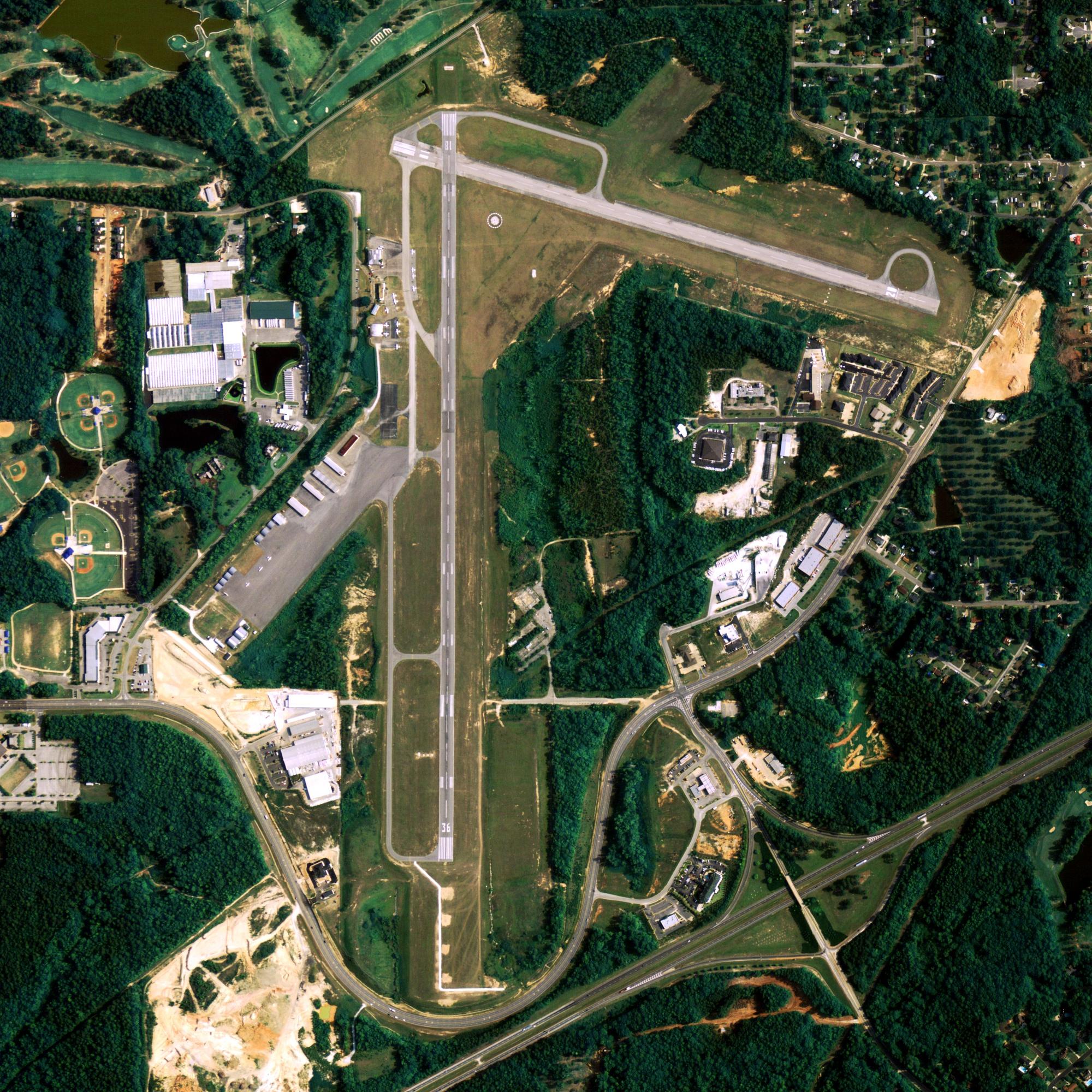
Location
| FAA Identifier: | EDF |
| Lat/Long: | 61-15-04.8715N 149-48-23.4924W 61-15.081192N 149-48.391540W 61.2513532,-149.8065257 (estimated) |
| Elevation: | 213 ft. / 64.9 m (surveyed) |
| Variation: | 18E (2015) |
| From city: | 3 miles NE of ANCHORAGE, AK |
| Time zone: | UTC -9 (UTC -8 during Daylight Saving Time) |
| Zip code: | 99506 |
Runway Information
Runway 6/24
| Dimensions: | 10000 x 200 ft. / 3048 x 61 m | ||||
| Surface: | asphalt | ||||
| Weight bearing capacity: |
|
||||
| Runway edge lights: | high intensity | ||||
| RUNWAY 6 | RUNWAY 24 | ||||
| Latitude: | 61-14.918000N | 61-15.202667N | |||
| Longitude: | 149-50.655667W | 149-47.300333W | |||
| Elevation: | 174.5 ft. | 201.3 ft. | |||
| Traffic pattern: | left | right | |||
| Runway heading: | 062 magnetic, 080 true | 242 magnetic, 260 true | |||
| Markings: | nonprecision, in good condition | nonprecision, in good condition | |||
| Visual slope indicator: | 2-light PAPI on left (3.00 degrees glide path) RY 06 PAPI UNUSBL BYD 8 DEGS EITHER SIDE OF COURSE PATH. |
4-light PAPI on left (3.00 degrees glide path) PAPI RY 24 UNUSBL BYD 7 DEG RGT OF COURSE. |
|||
| RVR equipment: | touchdown | touchdown | |||
| Approach lights: | ALSF1: standard 2,400 foot high intensity approach lighting system with centerline sequenced flashers (category I) APCH LGTS EXTND 15 FT ABOVE SFC UP TO 100 FT PRIOR TO THLD. |
||||
| Runway end identifier lights: | no | no | |||
| Centerline lights: | yes | yes | |||
| Touchdown point: | yes, lighted | yes, no lights | |||
| Instrument approach: | ILS | ||||
| Obstructions: | none | pline pole, 1000 ft. from runway, 20:1 slope to clear | |||
Runway 16/34
| Dimensions: | 7493 x 150 ft. / 2284 x 46 m | ||||
| Surface: | asphalt | ||||
| Weight bearing capacity: |
|
||||
| Runway edge lights: | high intensity | ||||
| Gradient: | N. | ||||
| RUNWAY 16 | RUNWAY 34 | ||||
| Latitude: | 61-15.723833N | 61-14.494000N | |||
| Longitude: | 149-47.608667W | 149-47.609500W | |||
| Elevation: | 212.5 ft. | 184.9 ft. | |||
| Traffic pattern: | left | right | |||
| Runway heading: | 162 magnetic, 180 true | 342 magnetic, 360 true | |||
| Markings: | basic, in good condition | basic, in good condition | |||
| Visual slope indicator: | 4-light PAPI on left (3.00 degrees glide path) | 4-light PAPI on left (3.00 degrees glide path) | |||
| Runway end identifier lights: | no | no | |||
| Touchdown point: | yes, no lights | yes, no lights | |||
| Obstructions: | trees hill, 1200 ft. from runway, 12:1 slope to clear | pline tree, 1000 ft. from runway, 18:1 slope to clear | |||
Other nearby airports with instrument procedures:
- PAMR – Merrill Field Airport (3 nm SW)
- PAFR – Bryant Army Airfield Heliport (5 nm E)
- PANC – Ted Stevens Anchorage International Airport (7 nm SW)
- PAGQ – Big Lake Airport (17 nm N)
- PAWS – Wasilla Airport (21 nm N)

airport-image-3

airport-image-4
Anchorage Quick Info
Country: USA
State: Alaska
Area
1,944.05 sq mi (5,035.06 km2)
Coordinates 61°13′N 149°54′W
Population
291,538 (2018 est)
Density
170.81/sq mi (65.95/km2)
Time zone
UTC-9 (AKST)